RescueNET

Motivation

 The proposed mobile application is a management system for smartphones and tablets that combines Earth Observation and collaborative spatial data to assist teams to cooperate in an efficient way under a geographic area in need.


Concept

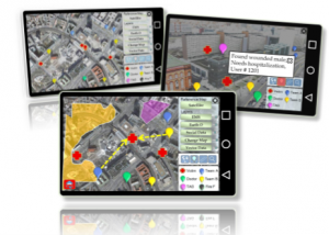
RescueNet is a mobile App designed to integrate Earth Observation and social data for advancing management in emergency and collaborative environments. The main idea is that accredited users of various levels (i.e., doctors, volunteers, firefighters, people in need, first responders) navigate in the area of interest with their mobile device and share spatial tags, information, photos etc.
Base maps derived from Earth observation platforms, and open background maps are used to enable visualization and provide guidance to reach problematic areas.


Functions

Applications

RescueNET applications concern human lives and infrastructure – economy:

•Natural Disasters: forest fires, earthquakes, floods, volcanoes, tsunamis, etc.

• Industrial Accidents: mining industry, etc.

• Transportation Accidents: rockfall, airplanes, etc.

• Other incidents: Refugee crisis, search and rescue, humanitarian aid, emergency response, etc,

• Environmental monitoring, agriculture, ocean,

• Tourism, Public Safety.

Innovation

• Involve near real time EO imagery derived from initiatives such as Copernicus Emergency Management Service,

• Real time, Dynamic monitoring of all participants, victims and needs,

• Navigation can be realized in a classic 2D or in a 3D intuitive environment under tilted view for enhanced visualization,

• RescueNET is a platform that can easily support any type of collaborative mission, providing a robust and insightful means for a mobile social network system,

• Inspiration for other relative applications: Environmental, biodiversity, agriculture, culture, democracy apps are envisioned,

RescueNET promotes citizen’s Participation